Archived Plans and Projects
Below you can browse for documents related to major projects, environmental analysis, and plans in the Tahoe Basin.
2020 Regional Transportation Plan and Environmental Analysis
Final 2020 Regional Transportation Plan – Executive Summary
Final 2020 Regional Transportation Plan – Full Plan
Chapter 1 Introduction
Chapter 2 Planning Context
Chapter 3 The Plan
Chapter 4 Funding the Plan
Chapter 5 Measuring and Managing for Success
Chapter 6 Moving Forward
Statements, Acknowledgements, Resources List, and Glossary
Appendix A: Goals and Policies
Appendix B: Project List
Appendix C: Revenue Narrative
Appendix D: Innovation in Transportation
Appendix E: Public Participation
Appendix F: Environmental Justice
Appendix G: Data and Forecasting
Appendix H: Congestion Management Process
Appendix I: Performance Measures
Appendix J: Regional Plan Checklist
Final Draft 2020 Regional Transportation Plan IS/IEC
2020 RTP IS/IEC Appendices
Shoreline Plan
Final Environmental Impact Statement (EIS)
Introduction
Revisions to the Plan
Comments & Responses
Comments & Responses to Agencies
Comments & Responses to Organizations
Comments & Responses to Individuals
Comments & Responses to Oral Comments at Public Meetings
Revisions to the Draft Environmental Impacts Statement
References
List of Preparers
Appendices
Appendix A Shoreline Implementation Program
Appendix B Comment Letter Attachments
Appendix C Revised Watercraft Emissions Calculations
Public Draft Environmental Impact Statement (EIS)
Executive Summary
Introduction – Table of Contents
Project Description
Approach
Land Use
Fish and Aquatic Biological Resources
Hydrology and Water Quality
Soil Conservation
Recreation
Scenic
Air Quality
Greenhouse Gas Emissions and Climate Change
Noise
Transportation
Terrestrial Biological Resources
Public Health and Safety
Cultural Resources
Cumulative Impacts
Other TRPA Mandated Sections
References
Report Preparers
Full Shoreline EIS
Appendices
Appendix A Watercraft Use & Buildout
Appendix B Scoping Report
Appendix C Emission Calculations
Appendix D Noise Data
U.S. Coast Guard EA EIS NOS
U.S. Coast Guard EA EIS NOS
Coast Guard EA EIS
Notice of Draft
Notice of Completion
Tahoe Summary Form Document
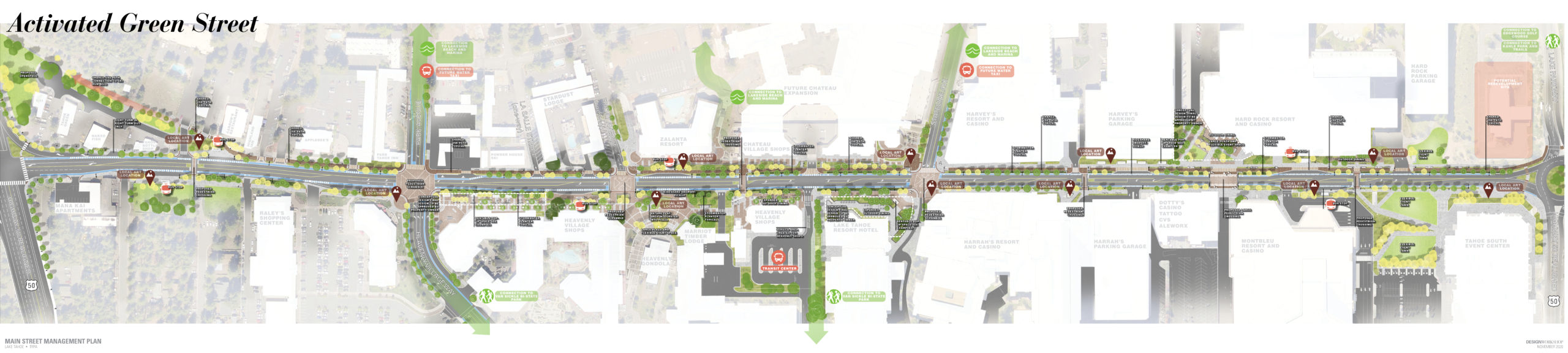
Final Main Street Management Plan
Washoe County Tahoe Area Plan
U.S. 50/South Shore Community Revitalization Project EIR/EIS
Cover – Title Page
Table of Contents
Summary
1 Introduction
2 Project Alternatives
3 Affected Environmental Consequences
4 Other Mandated Sections
5 Comments & Coordination
6 References
7 List of Preparers
8 Distribution List
Volume 2
Cover – Title Page
Table of Contents
Appendix A
Appendix B
Appendix C
Appendix D
Appendix E
Appendix F
Appendix G
Appendix H
Appendix I
Appendix J
Appendix K
Appendix L
Appendix M
Appendix N
Appendix O
Appendix P
Appendix Q
Appendix R
Draft U.S. 50/South Shore Community Revitalization Project EIR/EIS
Approach to Environmental Analysis
Parks and Recreation Facilities
Water Quality and Stormwater Runoff
Geology, Soils, Land Capability, and Coverage
Relationship Between Short-Term, Long-Term
Irreversible and Irretrievable
Appendix A US 50 Scoping Report
Appendix B Maps of Parcel Acquisition
Appendix C Alternatives Dismissed
Appendix G Draft Visual Impact Assessment
Appendix H Non-Discrimination Statement
Appendix I Traffic Operations Analysis
Appendix J AQ-GHG Modeling Data
Placer County Tahoe Basin Area Plan and Tahoe City Lodge EIR/EIS
FINAL Placer County Tahoe Basin Area Plan and Tahoe City Lodge EIR/EIS
Notice of availability final RIR
Cover-Title Page
Table of Contents
1 Introduction
2 Revisions
Chapter 3 – Response to Comments
3.1 Master Responses
3.2 Agency comments and responses
3.3 Organization comments and responses
3.4.1 Individual comments and responses
3.4.2 Individual comments and responses
3.4.3 Individual comments and responses
3.5 Public hearing comments and responses
4 Mitigation monitoring and reporting program
5 Report preparers
6 References
Appendices:
Appendix A : Revised Tahoe City Lodge Concept Plan
Appendix B: Comment Letter 12 Attachment
B Part 1
B Part 2
B Part 3
Appendix C : Comment Letter 13 Attachment
Appendix D : Comment Letter 15 Attachment Appendix E : Comment Letter 20 Attachment Appendix F : Comment Letter 69 Attachment
Appendix G : Comment Letter 82 Attachment
Appendix H : Comment Letter 99 Attachment
Appendix I : Comment Letter 100 Attachment
Appendix J : Comment Letter 105 Attachment
Appendix K : Placer County and TRPA Joint Statement of Regional Transit Principles
Appendix L : Corrected Appendix G-2
Appendix M: Comment Letter 10 Attachment
M Part 1
Placer County Area Plan Webpage
DRAFT Placer County Tahoe Basin Area Plan and Tahoe City Lodge EIR/EIS
Cover
TOC
01 Introduction
02 Executive Summary
03 Alternatives
04 Approach to Env Analysis
05 Land Use
06 Pop & Housing
07 Biological Resources
08 Cultural Resources
09_Scenic Resources
10 Transportation Circulation
11 Air Quality
12 GHG & CC
13_Noise
14 Geology Soils
15 Hydrology
16_Public Svcs & Utils
17 Recreation
18_Hazards
19_Cumulative
20 Other Mandated Sections
21 Report Preparers
22 References
23 MMRP
Appendix A_NOP and Scoping Report
Appendix B_Mixed Use Permissible Land Uses
Appendix C_Lodge Floor Plans
Appendix D_Lodge Conceputal Plans
Appendix E_Species tables
Appendix F_TC Lodge Historic Resources Rpt
Appendix G_Transportation and Circulation_revised 6_2
Appendix H_Air Quality
Appendix I_Greehouse Gas
Appendix J_Noise Supplemental Information
Appendix K_Mixes Use Area Soil Hazard Rating
Kings Beach State Recreation Area and Pier
Kings Beach State Recreation Area and Pier Notice of Preparation
Direct link to plan on California State Parks Website
Preliminary General Plan Revision and Kings Beach Pier Rebuild Project Draft EIR/EIS
Greenhouse Gas Emissions & Climate Change
Appendix B Visual Magnitude Calculations
Kings Beach State Recreation Area and Pier Final EIS
Cover
(click here) to download the Final EIS Cover.
Table of Contents
(click here) to download the Final EIS Table of Contents.
Introduction
(click here) to download the Final EIS Introduction.
Responses to Comments
(click here) to download the Final EIS Responses to Comments.
Revisions to DEIR-EIS
(click here) to download the Final EIS Revisions to DEIR-EIS.
References
(click here) to download the Final EIS References.
Report Preparers
(click here) to download the Final EIS Report Preparers.
SR 89/Fanny Bridge Community Revitalization Project Final EIR/EIS
The Final document is very large and has been broken into sections for quicker downloading:
Table of Contents
Chapters 1 and 2
Chapter 3 – Pages 3-1 to 3-413
Chapter 3 – Pages 3-414 to 3-692
Chapters 4 and 5
State Route 89/Fanny Bridge Community Revitalization Project
SR89_NOA DIER_DEIS_12_15_14_FINAL
Draft State Route 89/Fanny Bridge EIR/EIS/EA
Apdx A_SR 89-Fanny NOP
Apdx B_SR 89 Fanny Bridge Scoping Report
Apdx C_Final Fanny Bridge AQ 041414
Apdx D_Land Use Consistency Tbl
Apdx E_Fanny Bridge NSR
Apdx F_Section F Doc
Apdx G_Traffic Data
Nevada Stateline to Stateline Bikeway North Demonstration Project
The Notice of Availability, Comment, and Public Hearings for the Joint TRPA and NEPA Environmental Assessment for the Stateline-to-Stateline Bikeway, North Demonstration Project in Incline Village, NV has been released. The comment period starts March 5, 2014 and concludes on April 11, 2014.
View the Draft Environmental Assessment
The Federal Highway Administration and TRPA have directed the preparation of a joint Environmental Assessment (EA) pursuant to National Environmental Policy Act (NEPA) regulations, TRPA’s Compact, and Chapter 3 of the TRPA Code of Ordinances for the Nevada Stateline-to-Stateline Bikeway, North Demonstration Project (Project). The proposed Project is an approximately three mile section of the longer Nevada Stateline-to-Stateline Bikeway Project, which is a proposal to build a premier, shared-used path on the east side of Lake Tahoe between the Nevada state line in Crystal Bay on the north and the casino corridor in Stateline, Nevada on the south. The Project is proposed to be a shared use path connecting Incline Village and Sand Harbor in Washoe County, Nevada on the east shore of Lake Tahoe.
The North Demonstration Project is a high priority section of the larger Nevada Stateline-to-Stateline Bikeway, which encompasses an approximately 30-mile corridor between the Nevada state line in Crystal Bay and the casino core in Stateline, Nevada. This notice addresses only the North Demonstration Project. The first section of the overall project, the South Demonstration Project, between the Stateline casino core and Round Hill Pines Beach, has been approved and construction of this segment is scheduled for the summer of 2012. The alignment between the South and North Demonstration Projects and the alignment between Incline Village and Crystal Bay are undergoing additional alignment planning; future implementation phases will be subject to their own environmental review and are not being evaluated as part of this effort, except in the cumulative context.
More detailed information and maps of the proposed project can be accessed on the project website at www.tahoetransportation.org.
Lake Tahoe Passenger Ferry Project
The Tahoe Transportation District (TTD) is proposing the development of an all-season, passenger ferry service between the north shore and south shores of Lake Tahoe. The proposed ferry service would improve mobility within the Lake Tahoe Region, reduce vehicle miles traveled by automobile, and move the Region toward achievement of the regional water quality, air, and GHG goals.
View Notice HERE
Community Enhancement Program
The (Community Enhancement Program) is bringing more rapid environmental gains for the Lake Tahoe Basin through projects which implement environmental improvements, enhance quality of life for residents, improve the visitor experience and contribute to the long-term economic vitality of the Region. The CEP is demonstrating what Lake Tahoe communities can look and feel like over the next 20 years if substantial improvements to our commercial core areas can be encouraged.
Of the original nine CEP proposals, seven projects are still in the program and one, Boulder Bay, has already been permitted. See the links above for more details on each of the projects.
The focus of the CEP is to encourage revitalization projects in downtown and recreation areas that demonstrate substantial environmental, as well as social and economic benefits. The program provides incentives for mixed-use development projects on existing disturbed or underutilized sites. The CEP is competitive and is designed to encourage the “best” projects that will demonstrate the desires of the community captured in the Regional Vision. The Community Enhancement Program is a collaboration between the Tahoe Regional Planning Agency, the community, and local government partners. The program provides a means to demonstrate implementation of the Regional Vision through the implementation of selective projects.
The CEP builds upon (Special Programs) criteria in the TRPA Code of Ordinances and incorporates elements of the Regional Vision obtained through the Placed Based planning process. These elements further clarify the goals of Special Projects and are aimed to assist in moving the Lake Tahoe Basin toward attainment of environmental thresholds.
The program is front-loaded to shape projects early in the design stages to ensure they meet the criteria, rather than react to projects that are completely designed before submittal. It is hoped that these projects, in turn, will be catalysts for further upgrade of Basin community centers, transit nodes and neighborhood centers. This is not a code avoidance program and all proposals designated CEP projects must pass TRPA’s thorough environmental review and compliance processes
(click here) to download the Regional Vision obtained through Place Based Planning workshops held around the lake in 2005 and 2006 (2.1 MB).
(click here)to read the program summary and guidelines of the CEP (Timeline updated 12-27-07).
(Frequently Asked Questions)
(News Release July 27, 2007)
(TRPA Editorial September 28, 2007)
(TRPA Editorial November 20, 2007)
(News Release November 2, 2007)
TRPA, local jurisdictions and the property owners hosted community workshops in 2007 to gather additional input to ensure that any projects chosen to participate in the program are in alignment with the community’s vision. The CEP is designed to be as open, transparent, and community-based as possible.
The TRPA Governing Board approved staff recommendations to designate all nine pre-applications as CEP projects in 2008. As part of this approval, the project concepts were each assigned future commodities in the form of development rights reserved by TRPA for special projects. All projects have to apply to TRPA and undertake environmental review. In some cases, TRPA staff may recommend modifications to the TRPA Code of Ordinances for a CEP project to be approved. These modifications must be approved prior to project approval through a separate action by the Governing Board.
As a part of the 2012 Regional Plan Update, the Community Enhancement Program expired. The update includes policies supporting the transfer of development bonus units. No new Community Enhancement Program applications are being accepted.
Tahoe South Events Center Project Environmental Assessment
Cover, Title Page, Table of Contents, Executive Summary, Chapter 1, Chapter 2 Track Changes
Chapter 3
Chapter 3.5 Track Changes
Chapter 3.6 Track Changes
Chapter 3.7 Track Changes
Appendices
- TSEC EA Scoping Summary Report
B. Project Design/Plan Sheets
C. Construction Dewatering Plan (Welsh Hagen, 2019)
D. Technical Memoradndum Regarding Groundwater Interception (Welsh Hagen, 2019)
E. USFWS Species List
F. Transportation Supporting Analysis (LSC, 2019)
G. TSEC CalEEMod AQ/GHG Model Results
H. Scenic Quality Evaluation Report
Lake Tahoe Community College Master Plan and University Center
Brockway Campground
Heavenly Epic Discovery FINAL EIR/EIS/EIS
Heavenly Environmental Monitoring AR 2015
Appendices
FINAL EIR/EIS/EIS listed by Chapter
*Due to large file size, some chapters have been uploaded in sections.
Cover
Table of Contents
Executive Summary
1.0 Introduction
2.0 Proposed Action
3.01 Hydrology
3.02 SEZ Wetlands
3.03 Water Use
3.04 Geology Soils
3.05 AQ Climate Change
3.06 Noise
3.07 Traffic
3.08 Vegetation
3.09 Wildlife
3.10 Visual
3.11 Cultural
3.12 Land Use
3.13 Recreation
3.14 Socioeconomics
4.0 Mandated
5.0 MMP
6.0 Preparers References
Cover FEIR Volume II Responses
7.0 Volume II Responses to Comments Part 1
7.0 Volume II Responses to Comments Part 2
7.0 Volume II Responses to Comments Part 3
Appendix 3.1-A WQ Compliance Revised
APPENDICES ALL FEB 2015 Part 1.a
APPENDICES ALL FEB 2015 Part 1.b
APPENDICES ALL FEB 2015 Part 1.c
APPENDICES ALL FEB 2015 Part 1.d
APPENDICES ALL FEB 2015 Part 2
APPENDICES ALL FEB 2015 Part 3.a
APPENDICES ALL FEB 2015 Part 3.b
APPENDICES ALL FEB 2015 Part 4
APPENDICES ALL FEB 2015 Part 5
Heavenly Epic Discovery Park
View Notice HERE
To view complete EIS/EIS/EIR click HERE
DRAFT Heavenly Epic Discovery EIR/EIS/EIS
DRAFT EIR/EIS/EIS listed by Chapter
Executive Summary
Table of Contents
1.0 Introduction
2.0 Proposed Action
3.01 Hydrology
3.02 SEZ Wetlands
3.03 Water Use
3.04 Geology Soils
3.05 AQ Climate Change
3.06 Noise
3.07 Traffic
3.08 Vegetation
3.09 Wildlife
3.10 Visual
3.11 Cultural
3.12 Land Use
3.13 Recreation
3.14 Socioeconomics
4.0 Mandated
5.0 MMP
6.0 Preparers References
Epic Discovery NOA
Appendices
Appendices by Section
Scoping Summary and Comments
Advenutre Peak, East Peak Lake, Sky Meadows Activities
Erosion Assessments
Emissions and Traffic
Consistency Review
Heavenly Mountain Resort Master Plan and Monitoring
Mitigation and Monitoring Reports
2022-2023
Heavenly Mitigation and Monitoring Annual Report (2023) with Appendices
2021-2022
Heavenly Mitigation and Monitoring Annual Report (2022) with Appendices
2020-2021
Heavenly Mitigation and Monitoring Annual Report (2021) with Appendices
Comprehensive Report 2017-2021
Heavenly 5-Year Comprehensive Report (2017-2021)
2019-2020
Heavenly Mitigation and Monitoring Annual Report (2020) with Appendices
2018-19
Heavenly Mitigation and Monitoring Annual Report (2019) with Appendices
2017-18
Heavenly Mitigation and Monitoring Annual Report (2018) with Appendices
2016-17
Heavenly Mitigation and Monitoring Annual Report (2017) with Appendices
Comprehensive Report 2012-2016
Heavenly 5-Year Comprehensive Report (2012-2016)
2015-2016
Heavenly Mitigation and Monitoring Annual Report (2016) with Appendices
Comprehensive Report 2006-2011
Heavenly 2006-2011 Comp Annual Report Revised July 2014
2014-15
Heavenly Mitigation and Monitoring Annual Report (2015) With Appendices
2013-14
Heavenly Mitigation and Monitoring Annual Report (2014) With Appendices
2012-2013
Mitigation and Monitoring Report 2012-2013 with Appendices
2011-2012
Mitigation and Monitoring Report 2011-2012 with Appendices
2010 – 2011
Mitigation and Monitoring Report 2010-2011 with Appendices
2009-2010
Mitigation and Monitoring Report 2009-2010 with Appendices
2008-2009
Mitigation and Monitoring Report 2008-2009 with Appendices
Resort Master Plan Adopted April, 2007
California Pacific Electric Company 625/650 Electrical Lines Upgrade Project
Notice of Availability/Comment Period and Instructions for Public Comment November 8, 2013
CalPeco DEIS-EIS-EIR Appendices
Notice of Preparation and Notice of Intent
CalPeco FEIS/EIS/EIR Documents
CalPeco FEIS-EIS-EIR Appendices – Part 1
CalPeco FEIS-EIS-EIR Appendices – Part 2
CalPeco FEIS-EIS-EIR Appendices – Part 3
Appendix P Comments and Responses to Comments
Appendix P4 Response to NTCAA February 14 Comments and Supporting Documents
USFS Tech Reports
CalPeco Migratory Landbirds Report
CalPeco Riparian Conservation Objective Analysis
CalPeco Threatened, Endangered and Sensitive Plants and Fungi Report
CalPeco Invasive Plant Risk Assessment
CalPeco Aquatic and Terrestrial Species Report
CalPeco Management Indicator Species Report
Draft Record of Decision and Objection Letter Instructions
Edgewood Lodge
The Tahoe Regional Planning Agency Governing Board approved the Edgewood Tahoe Lodge and Golf Course realignment project on August 23 in a unanimous vote.
The Board voted to certify the project’s Final Environmental Impact Statement, approved a code amendment for the height amendment and approved the 154-room hotel project that includes environmental improvements to water quality as well as sensitive land restoration.
Notice of Availability and Public Hearing
(click here) to download the Notice Of Availability of the Final EIS and Public Hearing.
Final Environmental Impact Statement
(click here) to download the Final EIS (14 MB).
Edgewood Lodge Draft Environmental Impact Statement
Notice of Availability, Opportunity to Comment and Public Hearing
(click here) to download the Revised Notice Of Public Hearing.
NOTE: The previously-scheduled May 30 hearing has been cancelled.
(click here) to download the original Edgewood Notice of Availability.
Edgewood Draft Environmental Impact Statement
(click here) to download the Edgewood DEIS (58 MB).
Edgewood Draft Environmental Impact Statement Appendices
(click here) to download the Edgewood DEIS Appendices (89 MB).
Edgewood Lodge & Golf Course Improvement Project
Notice of Preparation of an EIS
(click here) to download the Edgewood NOP (1 mb).
The Notice of Preparation of an Environmental Impact Statement was circulated from June 1 to July 15, 2009. A scoping meeting was held during the TRPA Governing Board meeting Wednesday, June 24 at TRPA offices in Stateline, NV. Click on the meeting schedule link above for the staff summary of the meeting.
Homewood
At its December 2011 meeting, the TRPA Governing Board voted to approve the Homewood Master Plan and certify the Final Environmental Impact Statement that were 5 years in the making.
Litigants brought forward a lawsuit against Placer County and the TRPA in January, 2012. The lawsuit is ongoing.
The planned resort upgrades aim to keep the historic ski resort through sustainable development.
Additional documentation in response to comments on the Homewood Master Plan and FEIS
(Public Notice of Governing Board Hearing and Description of Action Items Being Requested)
(Description of Action Items to be Considered by the Governing Board)
(Homewood Master Plan Public Comments from Friends of the West Shore, Tahoe Area Sierra Club, The League to Save Lake Tahoe)
(Homewood Master Plan Public Comments Received to December 5, 2011)
(Master Plan Air Quality and Greenhouse Gas Analysis for the Transfer of Tourist Accommodation Units/Existing Residential Units)
(Master Plan Trip Generation and VMT Analysis for the Transfer of Tourist Accommodation Units/Existing Residential Units)
(Statement of Qualifications for Financial Analysis)
Proposed Master Plan, Updated August 2011
(Introduction and Executive Summary) 31 MB
(Physical Plan) 6 MB
(Regulatory Consistency and Other Plans) 3.5 MB
The Homewood Mountain Resort Community Enhancement Program (CEP) concept encompasses the base of Homewood ski resort and mid-mountain lodge. The concept is participating in the CEP while continuing its Master Plan process.
The Final EIR/EIS for this project was made available October 3 and is being circulated for public review before Placer County Supervisors and the Tahoe Regional Planning Agency Governing Board can take action on the study or the project. Multiple public hearings are listed at right to further discuss the final document. The TRPA Governing Board is expected to consider the Final EIS for certification at its December 14 meeting. The Board must vote to certify the Final EIS for adequacy and then consider adopting the Master Plan in a separate vote in order for the applicant’s proposed project to be approved.
The Notice of Availability below contains a public meeting schedule and details on where to view a copy of the Final EIR/EIS
(Notice of Availability)
October 3, 2011
Placer County and TRPA have prepared the joint Final EIR/EIS to inform agency decision makers about the potential environmental effects of the proposed HMR Master Plan. This joint document will serve as an EIR prepared by the County of Placer pursuant to the California Environmental Quality Act (CEQA) and an EIS prepared by TRPA pursuant to its Compact and Chapter 5 of the Code of Ordinances.
Final Environmental Impact Statement
Final Environmental Impact Report/Statement
Final Environmental Impact Report/Statement Appendices
(Maritime Electrical Installations and Diesel Electric Propulsion References)
(Alcatraz Cruises References)
(California Air Resources Board References)
(Hybrid-Marine Ltd References)
(Schneider-Electric References)
(U.S. Environmental Protection Agency References)
(World Water Taxi References)
(Maritime Electrical Installations and Diesel Electric Propulsion References)
(Alcatraz Cruises References)
(California Air Resources Board References)
(Hybrid-Marine Ltd References)
Draft Environmental Impact Report/Statement
Draft Environmental Impact Report/Statement Appendices
Air Quality References
CC References
Noise References
Shared Parking References
Traffic References
Hydro References
Boulder Bay
TRPA BOARD APPROVES BOULDER BAY PROJECT
At its April 2011 meeting, the Tahoe Regional Planning Agency Governing Board voted to approve the Boulder Bay Community Enhancement Project. Four years in the planning, the project will replace the aging Tahoe Biltmore Casino in Crystal Bay, NV with an eco-friendly, mixed-use resort that will significantly reduce stormwater pollution and vehicle emissions associated with the site.
“With science showing us that we can reverse the decline of Lake Tahoe’s clarity by encouraging environmental redevelopment of our town centers, the cost of doing nothing is just too high for the Lake,” TRPA Director Joanne Marchetta said. “Redevelopment projects like Boulder Bay are an important part of the public-private effort to restore Lake Tahoe.”
Once complete, the Boulder Bay site will include a mix of whole ownership condos, hotel units, affordable housing, a small casino, a health and wellness spa, retail and dining space, pedestrian and transit improvements, and a 4-acre community park. In addition, the project plans to pursue LEED certification, a global standard for green building techniques.
Click here to view the full news story.
Final Environmental Impact Statement
Boulder Bay Resorts
Community Enhancement Program Project
Crystal Bay, Nevada
Final Environmental Impact Statement (FEIS)
Notice of Availability of Final EIS
Draft Environmental Impact Statements
Boulder Bay Resorts
Community Enhancement Program Project
Crystal Bay, Nevada
Final Environmental Impact Statement (FEIS)
Click here to view a presentation shown at the TRPA Governing Board meeting November 18, 2009.
Beach Club Resort
The Beach Club on Lake Tahoe project was approved by the TRPA Governing Board in August, 2008. The project applicant, Beach Club, Inc., proposed to redevelop the existing Tahoe Shores Mobile Home Park located at the end Kahle Drive in Stateline, Nevada. The DEIS evaluated the potential environmental impacts associated with the proposed project (Alternative A), two separate development alternatives (Alternatives B and C), and two variations on the no-project alternative (Alternatives D and E).
Beach Club Draft Environmental Impact Statement January 2008
Meeks Bay Restoration Project
Meeks Bay Assessment
Stakeholder Forum: Terms of Reference & Meeting Plan
Meeks Stakeholder Forum Representatives
Meeting Agenda #1 – July 15, 2020
Meeks Forum #1 Presentation
Meeks Bay Forum #1 Finalized Summary
Forum Meeting #1 Link to Video Recording
Meeting Agenda #2 – August 5, 2020
Meeks Bay Forum #2 Presentation
Meeks Bay Forum #2 Finalized Summary
Forum Meeting #2 Link to Video Recording Password: wyAd4.e0
Meeting Agenda #3 – September 9, 2020
Meeks Bay Forum #3 Presentation
Meeks Bay Forum #3 Alternative Theme Diagrams with Questions
Forum Meeting #3 Link to Video Recording
Meeks Bay Forum Meeting #3 Final Summary
Meeting Agenda #4 – December 9, 2020
Meeks Bay Forum Meeting #4 Presentation
Forum Meeting #4 Link to Video Recording
Meeks Bay Forum Meeting #4 Draft Summary
Public Workshops:
Meeks Bay Public Workshop #2 Summary – January 7, 2021
Public Workshop #2 Meeting Recording
Meeks Bay Public Workshop #1 Summary – August 19, 2020
Public Workshop #1 Meeting Recording
Lake-Wide Control of Aquatic Invasive Plants
Tahoe Keys Lagoons Aquatic Weed Control Methods Test
Lake Tahoe West Restoration Project
Upper Truckee River and Marsh Restoration Project
NOTICE OF PREPARATION AND NOTICE OF PUBLIC SCOPING MEETING
Project Title:
Notice of availability of a Draft Environmental Impact Statement (EIS) and Environmental Impact Report (EIR), and notice of public hearing.
Upper Truckee River Restoration and Golf Course Reconfiguration Project
Final EIR/EIS Volume IV (65MB)
Final EIR/EIS Volume V (50MB)
PREPARATIONS TO FINALIZE THE DRAFT ENVIRONMENTAL STUDY OF THE UPPER TRUCKEE RIVER RESTORATION AND GOLF COURSE RECONFIGURATION PROJECT.
Over 700 comments were received during the public comment period for the Draft EIR/EIS/EIS. The comments are being reviewed by California State Parks, the Bureau of Reclamation and Tahoe Regional Planning Agency. The final document is expected to be released in early fall 2011. The document is an environmental impact report/environmental impact statement/environmental impact statement(EIR/EIS/EIS). The three titles are required for compliance with CEQA, NEPA, and TRPA review. Comments on the document were submitted between August and November, 2010.
Visit the Restore Upper Truckee web site to download the draft EIR/EIS/EIS.
California State Parks (State Parks) and the U.S. Bureau of Reclamation (BOR) are pursuing a restoration project along the reach of the Upper Truckee River that extends from its upstream entry point at the southern boundary of Washoe Meadows State Park to just west of U.S. Highway 50 where the river exits Lake Valley State Recreation Area. The project is being planned and proposed by State Parks. TRPA is managing the EIS process and helping gather public input as the process moves along.
Numerous public planning workshops, site tours and information sessions were held between 2007 to 2010 to present the project in detail to interested stakeholders and to gather input on the recreation uses in the parks.
The primary purpose of the project is to restore natural geomorphic and ecological processes along this reach of river and to reduce the river’s suspended sediment discharge to Lake Tahoe. The proposed restoration project would require reconfiguration of the Lake Tahoe Golf Course to allow for restoration of the river, reduce the area of stream environment zone occupied by the golf course, and allow for establishment of a buffer area between the golf course and the river. Alternatives to the proposed project are being considered and studied in the EIR/EIS/EIS.
A more detailed description of the proposed project is contained in the following documents:
Notice of preparation for EIS/EIR (2.4 MB)
Feasibility Study for the restoration project (929 K)
Diagrams for the Feasibility Study (21.1 MB). These were shown by the California State Parks and Recreation representative at the TRPA Governing Board meeting October, 2006.